Using Radio Mobile for Windows
Obtaining Elevation Data
Previous: Obtaining Elevation Data Next: Installing Elevation Data
Before you can really do anything with Radio Mobile you need to obtain the proper elevation data for the area in which you are creating plots. Radio Mobile accepts elevations in a number of formats including SRTM, DTED and GTOPO30. Fortunately most of this data is available free of charge and with a little effort is easily installed.
Install on Demand
The easiest way to obtain elevation data for Radio Mobile is to let the software download the data as needed. By default Radio Mobile will download elevation data if it is not found in your local path. This means that if Radio Mobile can not find any elevation data in the folder where it was installed it will download the necessary information from the Internet. In order to save yourself time and bandwidth in the future you should change this setting. To do so click on the Options menu and select "Internet." This will open a window as shown in Figure 2 below.
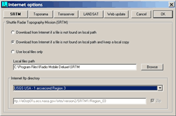
Figure 2: Radio Mobile Internet Options
You will see a row of buttons at the top labeled SRTM, Toporama, Terraserver, LANDSAT and Web Update. You will want to click on each button and make sure that "Download from Internet if a file is not found on local path and keep a local copy" is selected on each page. By setting this option Radio Mobile will save any elevation data you download to a folder which will speed up rendering of plots in the future. The local files path can be set to any folder on your computer or a network drive if you wish to share the downloaded data with other users on your local network.
Manually Obtaining Elevation Data
You may also choose to download and install elevation data manually. For instance, you might have Radio Mobile installed on a laptop and want to be able to use it in the field or perhaps you have elevation data other than what Radio Mobile can download. Using this data is easy but there are a few more steps involved.
GTOPO30
One type of elevation data Radio Mobile will not download automatically is GTOPO30. GTOPO30 is an elevation data model with a 30-arc second resolution developed by the USGS. The data is easily obtained from the USGS website.
To obtain GTOPO30 data you will first need to visit http://edc.usgs.gov/products/elevation/gtopo30/gtopo30.html. You will see a page that looks like Figure 3 with a map divided into grids. Click on the grid that corresponds to the area of the world in which you live and you will be taken to the appropriate download page. For an example see Figure 4. The file you download will be in tar.gz format, also know as a "tarball." On the next page, Installing Elevation Data, there is a quick tutorial on how to extract tarballs using 7-Zip.
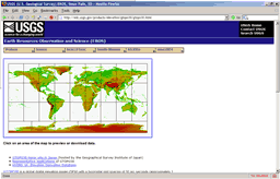
Figure 3: GTOPO30 Main Page
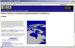
Figure 4: GTOPO30 Download Page
DTED
Radio Mobile also accepts elevation data in DTED format. DTED is not used as often now that higher resolution SRTM data is available however you might use DTED in situations similar to those mentioned above for GTOPO30. The process for obtaining DTED data is similar to that of GTOPO30 although the website used is not nearly as easy to navigate and merits a tutorial of its own. To download DTED data visit http://geoengine.nga.mil/muse-cgi-bin/rast_roam.cgi. You will see a page like Figure 5. Enter your latitude and longitude into the appropriate boxes and select DTED Level 0 from the "Available Product Levels:" dropdown box. Once you have done this click on the "Raster Roam" button and a map will be generated. If the map that appears to the left is not what you want you can adjust the image size and zoom factor as well as scroll the map.
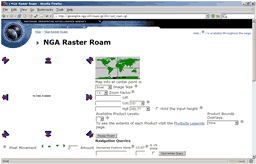
Figure 5: NGA Raster Roam
Once you have the map you want scroll to the very bottom of the page. Click on the button labeled "Raster Exporter" and the server will create a file for you to download that contains the data you selected. Please remember to click the "Delete" button at the bottom of the page after you have downloaded your data.
Now that you have downloaded terrain data you can continue on to the next step, Installing Elevation Data.
References
- 7-Zip Home Page
- National Geospatial-Intelligence Agency
- USGS Earth Resources Observation and Science
- United States Geological Survey